

Storm Éowyn was one of the most powerful and widespread wind events to hit Ireland since the so-called “night of the big wind” in 1839.
The last time Ireland experienced a storm like this one, there was no rural electrification, no telecommunications infrastructure, and virtually no cars on the roads.
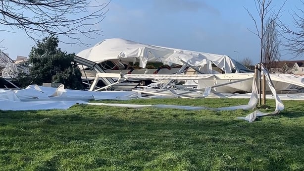
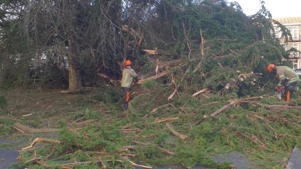
Storm Éowyn was a record-breaking storm, and the debris left in its wake is unprecedented.
The damage is nationwide, and the cost will be huge.
Social media is full of photos of fallen trees blocking Ireland’s roads, telephone pole snapped in two, electric wires downed, damage rooftops on houses and sheds, destruction to businesses and sports facilities too.
Éowyn was not a hurricane. But it must have felt exactly like one, to the people along the western seaboard where mean wind speeds exceeded hurricane force levels for much of the night.
Meteorologists say Éowyn was an extratropical storm rather than a hurricane.
Hurricanes usually form in a different way over warm seas that need to be at least 26C or more.
They behave differently to extratropical storms, have different shapes, and their strongest winds are located at a different location in their cloud formations.
Extratropical storms like Éowyn usually form over land rather than sea.
They are fuelled when enormous masses of extremely cold air are butted up against a huge mass of very warm air. The upshot is a chain of meteorological events that can supercharge wind speeds.
The bigger the difference or gradient in temperature between the hot and cold air masses when they meet, the stronger the winds will be.

Bitterly cold arctic air over the southeastern part of the United States crashing up against warm air in the Gulf of Mexico over the past week was the key to why Storm Éowyn became such a record breaker.
On this occasion the “crash” in air temperatures was so extreme it fuelled extraordinarily high wind speeds on this side of the Atlantic.
Met Éireann’s weather station at Ceann Mhása in Conamara, Co Galway, topped out with a sustained wind speed of 135km/h at 4am.
Within an hour, wind gusts measured at that same location were up to 183km/h.
Both measurements smashed Irish wind records that stood unbroken for the past 80 years.
The storm proceeded to break a range of other regional and local wind records elsewhere in the country.
Fortunately, this all happened while the entire country stood still.
Meteorologists have a name for what we have just lived through. They call it a “weather bomb”.
This is an accepted non-technical description for the rapidity with which storm Éowyn gained power right before it smashed into the west coast of Ireland.
The technical meteorological term is an “explosive cyclogenesis”.
That is too much of a mouthful for most of us of course. Hence the use of the far easier to understand alternative “weather bomb” description.
What they are referring to when using these terms is the rate of change in air pressure at the very centre of a storm. It is measured in millibars.
The faster the air pressure drops the stronger the winds will be.
At 60 degrees of latitude, meteorologists classify a drop of air pressure of 24 millibars in 24 hours as “explosive cyclogenesis”.
The air pressure at the centre of Storm Éowyn however, dropped by a massive 52 millibars in 24 hours before it landed.
This is far above the threshold required for a weather bomb and is unprecedented in modern times.
It was made even more impactful by the fact that this explosive cyclogenesis event was occurring just as the peak of the storm approached Ireland’s west coast.
If the cyclogenesis had happened hundreds of miles offshore, it might have left some time for the hurricane force winds to ease a little before they reached land.
Meteorologist could see all this forming in their charts and tracking models. It is why, even a day or two before it arrived, they were certain Éowyn would break records.
In the event the air pressure at the centre of the storm sank as low as 939 millibars – a record low for modern times.
So, make no mistake about it. This storm was an extraordinary event.
No doubt there will be a great temptation to see it as more evidence of climate change in action. But even the climate scientists themselves admit that is not the case.
There has not been enough research into the link between wind and climate change. Any research that has been done suggests mixed outcomes.
For instance, we know the Arctic is heating at least five times faster than the global average, and possibly eight times faster than the tropics.
This means the difference between air temperatures in both regions is growing smaller all the time. Yet air temperature difference is the key to wind speeds. The smaller the difference, the smaller the wind speeds and visa versa.
Some scientific studies have indicated that through this process wind energy around Ireland would weaken, not strengthen, because of climate change.
In truth however, a lot more research is needed before there will be scientific agreement around that.
This article was originally published by a www.rte.ie . Read the Original article here. .